Murals in the cities of South Africa
Many months of observation and documentation of the renewal of public art in the great cities of South Africa reveal a generous consumption of Geography, in the form of maps painted on walls by various "carto-graphic artists". Large and middle map scales are ignored . Instead, smaller map scales (whether national, continental or world scales) are favoured while maps of Africa are those most frequently painted. These can be found in many other places, such as on book covers, in advertising spaces, on CD covers, in jewellery designs, etc. But are these African maps actual geographic representations or are they the visible manisfestation of a cultural claim, or a claim of identity, in the form of affirmative action?
In the days of apartheid, city walls had more ears than power of speech. When they spoke, however, it was often with a vindictive but liberating violence, one which was exacerbated by the very real danger to which mural artists were exposed. Furtively scribbled slogans, such as "One settler, one bullet", did not exude a festive spirit; on the contrary, they urged the masses to mobilise against those who championed the established, yet iniquitous, system of law and order (Williamson 1989).
The liberation of Nelson Mandela, in 1990, followed by the multi-racial democratic elections of 1994, did not resolve the vast economic, social and racial disparities of the country. However, the aggression found in the language of murals, was sometimes replaced by humour, and by a constant search for the styles and colours inherited from various local traditions (Deliry-Antheaume 1997). In order to communicate new messages to a wider public, messages which are more societal, commercial and less political, pictures have often won over words and slogans, in the same way as stained glass, in the cathedrals of medieval Europe, educated a mostly illiterate population. Such pictorial attemps are nowadays perceived in a positive light and are no longer seen as the degradation of the environment.
The embellishment of public spaces by means of murals, which occurs more in the townships, is used as a controled means of communication, unlike in the rest of the city, in particular along highways and places with a high density of foot traffic (train stations, bus stations, taxi ranks, sports grounds, hospitals etc.). This public art, now less vindictive and more festive, uses colours in abundance: those of the South African flag , six colours, as well as all the other colours o the spectrum, thus illustrating one of the most debated metaphors in post-apartheid South Africa - that of the Rainbow Nation, a melting pot in in which "races" (an oddity which is still in use ) should combine harmoniously.
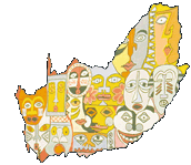
Both the sponsors' demand and the associated creativity of the artists, offer an exceptionally wide selection of pictorial styles which can range from the traditional to the modern, the figurative to the symbolic and the realistic to the allegoric. The messages expressed on murals are derived from within the geographic context in which the targeted public lives: the matchbox houses of the townships, the church, the school, the stadium, the power station with its cooling towers which dominate the horizon or hide the view, the blocks of flats of the city centre or even, as in the famous port of Cape Town, the silouhette of Table Mountain which overlooks the city. Mural artists often depict such a limited environment so as to relocate it in a much wider environment - a regional or global environment - hence the multitude of murals representing maps of the country, of the continent or of the world, which speaks of South Africa's obsession to confirm an African identity and to return to the world community of nations.
All these maps, which often have approximate outlines and landmarks - no boundaries, no networks, no place-names - do not have much geographic purpose. Rather, they are used to promote countless messages and declarations: logos of political parties, human rights campaign, Aids campaign, the fight for the protection of the environment, etc. From one wall to another, a few major trends can be seen,
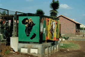
In the East Rand townships, the scene of the bloody rivalries of 1993-94 between the ANC and the IFP , painted slogans were used as territory markers by political parties who fought to control these areas. Most often, green-yellow-black flags, which bear the image of an assegaai and a shield (symbolising tradition) and the image of a wheel (symbolising progress), were used to demarcate ANC areas. With the flags were found also maps of Africa, with ANC colours. One must remember that the ANC was established in 1912, and that laid claim to the entire African continent.
 |
|
|
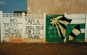
The desire to include the whole of Africa is also found on the PAC logo - which shows a continent with the star of the "socialist-africanist democracy" which radiates from the centre to Madagascar (the island is somewaht exaggerated by the artist). Next to this logo-map, slogans are found: "No peace without justice", "APLA will stick on its guns", even slogans which refer to other disputed parts of the world, such as "Sarajevo, Beirut or Vietnam", which attests to a good geopolitical knowledge.
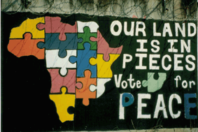
From the end of 1993, when political tension was still rife throughout the country, the electoral campaign was organised with substantial support from the media. The movement Lawyers for Human Rights then chose to use murals. Apart from encouraging civic duties and attesting to the confidentiality of the vote - "My vote is my secret" - a stylised map of Africa reminded voters from Pietermaritzburg of the scenario. The majority of these voters were voting for the first time in April 1994. The slogan played on two words: peace and pieces, the latter refering to the reintegration of the South African jigsaw puzzle piece into the African continent. This striking jigsaw puzzle evokes particularly well the instance of the missing piece which South Africa had become in its own continent.
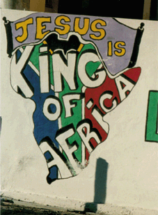
Although certain organisations do not have a wide geographic influence, they make abundant use of the map of Africa in association with, sometimes, the South African flag, to air their social views. This little indulgence might be politically correct as well as original, but it conveys the idea of a very real phenomenon which is of concern to neighbouring countries: that of South African regional imperialism. Also, in Cape Town, one can view such a map - a mixture of old-fashioned styles - which has no secret concerning convictions or patriotism: the South African flag covers the shape of the continent. While its message loudly sustains that "Jesus is king of Africa", another message on the side of it highlights that there is "No parking except on church business", thus indicating that the declaration of the sovereignty of the Heavens and the down-to-earth trivialities of the Republic can live next to each other.
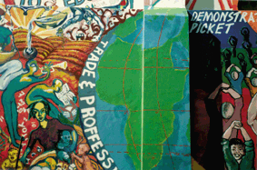
Within the range of maps painted on walls, the world map is featured frequently. In Durban, one such map highlights the universal character of human rights, while a map of Africa is represented simply, with its main parallels (equator, tropics) and meridians. The style of this map contrsts sharply with the effusion and the profusion of the allegorised theme which surrounds the map. The illustration of the right to education and the right to work increases the length of the Oceans and fills the top part of the planisphere, reminding one of the maps of earlier explorers on which, exotic fauna, flora and people filled the spaces of the terra incognita. On this mural, the vision of the world is afro-centric, while a step in the wall gives the impression of a folded map.
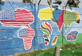
The most amazing world map is indisputably that which adorns the surronding walls of the stadium of Nyanga, a township of Cape Town. In the style of the circumnavigators who had not yet explored all the corners of the world they were discovering, carto-graphic artists have only an approximate knowledge of the geography of the world and yet, they show great perspicacity on the balance of power between the continents. The sections of the map attributed, respectively, to South America and Australia, do not bear their own flag. This world map is a true mental map (Houssay-Holzschuch 1995) which highlights the importance which South Africans attach to America and the fascination which America holds for South Africans, epitomized by Mickey Mouse and Coca-Cola (South Africa is the tenth biggest consumer of Coca-cola in the world). But one can also notice a significant African influence on the outlines of the South American portion of the map. Furthermore, remnants of the British Empire's influence appear only in Australia which is covered by the Union Jack. The United Kingdom is totally unrepresented on this world map. As to Europe, from which white South Africans originate, the colours and the contours used for its representation are unknown in the township. Europe is no more than the western tip of the Asian continent. India, from which a community of one million South African inhabitants originate, can be recognised easily. Africa itself is represented by the logo-map which was used by the Cape Town community during the bid to hold the Olympic Games of 2004. This symbolic map reflects the desire which South African have to be reintegrate, and to make the continent their own once more. The Olympic candidate city repeatedly expressed the idea, developed at length in its argumentation for the bid, that the wrongs done should be rectified by "entrusting" the Olympic Games to Africa. This outcome would then have "re-linked" the missing ring from the five-ring symbol of the Olympic institution. On the map, Cape Town is indicated with a large red dot - the only toponymic mark - and the continent is distinctly freed from Middle Eastern supervision. The Suez Canal and the Red Sea are as large as the Mediterranean Sea. Madagascar is oversized and one is not sure to which continent it relates. On the whole, this world map does not lack coherence in the mind of those who conceived and created it.
In this way, carto-graphic artists secure for themselves the map - over which geographers have no control or monopoly. Through it, they give us a different perception of the world. These African maps, devoid of boundaries and painted on small scales, represent not real, but rather, fantasised spatial illustrations. They manifest the desire to tell the world about the desolation or potential of a continent, the desire to recreate a strong African identity.
While the townships remian annoyingly blank on the official maps and thus do not constitute proper localities, a map painted as a mural represents, for everyone, the means to find not only one's way, but one's area and one's identity. It is a way to exorcise the geography inherited from apartheid (Christoher 1994). Freedom, I write your name; identity, I map out your contours.
CHRISTOPHER (A. J.), 1994, Atlas of Apartheid, Johannesburg, Witswatersrand University Press, 212 p.
Collectif, 1996-1997, South Africa Survey, Johannesburg, S.A.I.R.R, 912 p.
COSSER (M.), 1994, Maps for Africa, Albany Museum-Rhodes University, Grahamstown, 49 p.
DELIRY-ANTHEAUME (E.), 1997, L'art des rues: murs peints en Afrique du Sud, Autrepart, 1, hors texte, I-XVI, numéro spécial sur «Les arts de la rue dans les sociétés du Sud» (AGIER M. & RICARD A. éds)
HOUSSAY-HOLZSCHUCH (M.), 1995, Mythologies territoriales en Afrique du Sud, Paris, Ed. du CNRS, 104 p., coll. Espaces et milieux.
WILLIAMSON (S.), 1989, Resistance art in South Africa, Capetown-Johannesburg-London, David Philip & Catholic Institute for International Relations, 160 p.
Last update: August 27, 1999